google.com, pub-2829829264763437, DIRECT, f08c47fec0942fa0

Tuesday, October 9, 2018

Montreal's Old Port

Montreal's Old Port


The Old Port of Montreal is the historic port of this city. This site was used as early as 1611, when French fur traders used it as a trading post.

The historical Old Port was redeveloped in the early 1990s, under the direction of architects Aurèle Cardinal and Peter Rose.Today the Old Port offers Montrealers and visitors alike access to a wide variety of activities, including the Montréal Science Centre, with an IMAX Theatre, and the Montreal Clock Tower.

It offers riverfront access for walking, cycling, roller-blading, quadricycle, pedalo and Segway rentals. The area  as a popular destination for cycling, roller-blading and pleasure boating.

In June 2012, an urban beach, called the Plage de l'Horloge (Clock Beach), opened adjacent to the Clock Tower.

The historical Old Port was redeveloped in the early 1990s, under the direction of architects Aurèle Cardinal and Peter Rose. It is today a recreational and historical area. The Old Port offers Montrealers and visitors alike access to a wide variety of activities, including the Montréal Science Centre, with an IMAX Theatre, and the Montreal Clock Tower. It offers riverfront access for walking, cycling, roller-blading, quadricycle, pedalo and Segway rentals. The area as a popular destination for cycling, roller-blading and pleasure boating. In June 2012, an urban beach, called the Plage de l'Horloge (Clock Beach), opened adjacent to the Clock Tower. Every 2 years the Cirque du Soleil launches a new show from the Jacques Cartier Quay.

The Old Port is managed by the Old Port of Montreal Corporation, a subsidiary of Canada Lands Company, but it reports directly to the government.

In the 19th century, transporting goods along the St. Lawrence River was no simple task. Downstream near the Jacques Cartier Bridge, the Sainte-Marie current was so powerful that some boats had to be hauled through. Upstream in the western part of the river, the Lachine Rapids – the result of a 14-metre drop between Lake Saint-Louis and Laprairie Basin – thwarted the expansion of the port.

Until the turn of the 20th century, the sudden mid-winter thaws and inevitable spring ice jams considerably hindered the development of the port of Montreal. Masses of ice measuring up to 15 metres high caused devastating floods, including the most memorable flood of 1886. The repeated flooding prevented the construction of permanent infrastructures.

MacKay Pier (now known as Cité-du-Havre Point) was built between 1891 and 1898 to keep the ice flow in the St. Mary`s current and away from the shore. A cut stone firewall was built along de la Commune Sttreet in 1899. Finally protected, the port of Montreal could expand. Year-round navigation only became possible in 1964, when icebreakers started breaking the ice in order to open the St. Lawrence navigation canal.

De la Commune Street. This street separates Old Montreal from the Old Port. It stretches for over two kilometres along the St. Lawrence River in Old Montreal. 
The Souvenir Tower, also known as the Clock Tower (Tour de l'Horloge.
Old Port rapids.In the old times, the repeated flooding prevented the construction of permanent infrastructures.

Bonsecours bassin of the Old Port of Montreal.

Tour of  the Horloge (The Clock Tower).

Until the turn of the 20th century, the sudden mid-winter thaws and inevitable spring ice jams considerably hindered the development of the port of Montreal.

Old port of Montreal, general view.

Bonsecours Church as seen from the Old Port.

Bonsecours Bassin.
Upstream in the western part of the river, the Lachine Rapids – the result of a 14-metre drop between Lake Saint-Louis and Laprairie Basin – thwarted the expansion of the port.

Every 2 years the Cirque du Soleil launches a new show from the Jacques Cartier Quay.In the 19th century, transporting goods along the St. Lawrence River was no simple task.

Centre of Science in Old Port of Montreal.
A blue installation.
MacKay Pier (now known as Cité-du-Havre Point) was built between 1891 and 1898 to keep the ice flow in the St. Mary`s current and away from the shore.
A cut stone firewall was built along de la Commune Street in 1899.
Locks of love in the Old Port of Montreal.
Trails of  the Old Port.
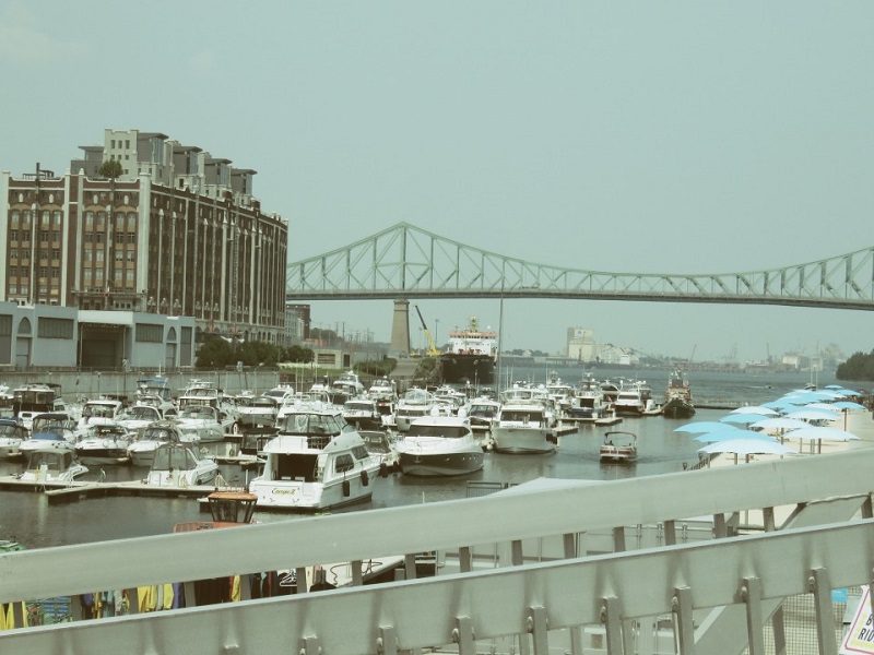
Cartier Bridge as seen from the Old Port.

Chunnel if by Land

Chunnel if by Land, Ferry if by Sea

London and France were joined by land for the first time since the Ice Age, in 1994


After years of work drilling the 31-mile tunnel out of the chalk bedrock beneath the English Channel, the $16 billion Chunnel - shorthand for Channel Tunnel - opened in 1994 with non-stop service between London and Paris.

The 300-mile trip between the two capitals takes about three hours on the 186-mph Eurostar bullet trains. That's substantially faster than a direct flight when you include taxi time from the airport to downtown.

You can"t drive through the chunnel, but will be able to transport your car on a train at prices that are competitive with those of regular ferries. Le Shuttle - the Franco-Anglo name for the car-train - costs hundreds of dollars for one car to go one way. Service started in late 1995, with a crossing-time just a few minutes under that of a standard hovercraft ferry.

Passenger fares are less competitive. A direct flight from London to Paris can be had for much less than the lowest-prices Eurostar ticket. For those looking for convenience and service, Eurostar may be just the ticket.

American and Canadian travelers can buy Eurostar tickets online or through a travel agent or else through ticket broker Britrail Travel International.

Celebrating the Chunnel, may be? Photo by Elena.

Monday, October 8, 2018

Grand Teton National Park

Grand Teton National Park


3 million visitors per year – 485 square miles – Best part of the beautiful Teton range.

There are not many places in the world where you can literally stand next to a mountain. Foothills usually intervene. Imagine then Grand Teton, where the mountains rise sharply out of the relatively flat Jackson Hole Valley like stark, granite skyscrapers.

Another geological oddity formed during the ice age, Jackson Hole Valley looks as if some gargantuan infant sculpted it out of Play-Doh. When the valley formed, little driblets from the glaciers formed rocky deposits, called moraines, around the six sparkling mountain lakes that were incongruously punctured into the landscape.

Winding gently through this stranger valley is the Snake River, along the bans of which grow willows, cottonwoods, and the blue spruces in which bald eagles prefer to nest. Beavers have built dams up and down the river, forming wetlands that have an incredibly dense concentration of wildlife, including bears, elk, moose, trumpeter swans, sandhill cranes, and Canada geese.

Peak season tips: From June through August, most of the crowds can be found near Jenny Lake, which has sand beaches and sometimes is warm enough for a quick swim.

Winter is coming. Photo by Elena.

Camping : Campgrounds are generally open from late May to October. In summer, Jenny Lake campground filles the fastest and has a seven-day camping limit – the other five parks have two-week limits. Camping at all six campgrounds is available on a first-come, first served basis except at Colter Bay Trailer Village, where reservations are required.

Best one-day trip: Beginning at the south entrance on Route 191, stop at Mentor's Ferry and the Chapel of the Transfiguration for a look at the dwellings of some of the area's first pionners. Then drive north along Teton Park Road to Lupine Meadow and take the spur road to the trail head, where there is a difficult hike to Amphitheater Lake near the timberline. Attempt this only if you are in good shape. Head back up Teton Road for a stop at South Jenny Lake, which is located at the bottom of the tallest Teton Peak. An easy six-mile hike there circles the lake and affords spectacular views of the mountain. Finally, stop at Colter Bay for a one-mile hike that loops around the wetlands and provides good opportunities for viewing the wildlife up close.

Best experience: In winter, horse-drawn sleighs take visitors to see the herd of 11,000 elk that live in the valley.

Newest National Parks

America's Newest National Parks

These desert lands are an oasis for those thirsting after beauty


Two new national parks and a new national preserve belie popular myths about American desert lands. Created by the 1994 California Desert Protection Act, Death Valley National Park, Joshua Tree National Park, and Mojave National Preserve, all in California's Mojave Desert, are not simply cactus-strewn sandboxes. In fact, they are practically teeming with some 700 species of plants and 760 species of wildlife, some of which are extremely rare.

And cultural artifacts also appear on the arid landscape, from mysterious ancient pictographs to the Boeing  burial ground, where the aircraft manufacturer has laid several 748s to rest.

Gas, water, food are few and far between, though, and summer daytime temperatures average more than 100 degrees. Make sure you consult a map carefully before you travel. The best months for visiting are October through May.

Death Valley National Park


At 5,000 square miles, it is now the largest national park in the lower 48 states. Badwater, the lowest and hottest place in the United States, is located here, but many of the mountains in the park can be chilly, even in the summer. Notable sites include Eureka Valley's 700-foot sand dunes and Scotty's Castle, the opulent home of an early prospector. Death Valley is probably the most visitor-friendly of the new national parks, with hotels, campgrounds, and even a golf course within its boundaries.

Joshua Tree National Park


National Monument Dr. Twentynine Palms, Ca.

Ansel Adams shot some of his most famous landscape photographs here. Home of the gnarly, 20- to 40-foot Joshua tree it is also a world-famous spot for rock climbing. Although there are adequate camping facilities in the park, one might want to stay instead in Tewntynine Palms or Palm Springs for the comforts of cilvilization.

Mojave National Preserve


Lake Mead National Recreation Are, 601 Nevada Highway, Boulder City, NV.

Initially proposed as a national park, but downgraded to a national preserve to allow hunting. With 19 mountain ranges, groves of white fir and Joshua trees, limestone caves, and extensive, ancient petroglyphs, there is plenty to keep one occupied. Of the new parks, however, the Mojave is probably the least equipped for visitors, with a few campgrounds and no towns nearby.

And cultural artifacts also appear on the arid landscape. Photo by Elena.

Acadia National Park

Acadia National Park


3 million visitors per year – 54 sqaure miles – the highest coastal mountains on the east coast.


The park is made of two islands and a peninsula: Mount Desert Island (which is accessible by a land bridge), Isle au Haut, and Schoodic Peninsula.

Artists and writers flocked to Mount Desert Island in the 1850s, attracted by its dramatic natural beauty and the rustic life it offered. Later, in the Gay 1990s, wealthy vacationers, inspired by the paintings, came and built “cottages” of a level of opulence that the country had not seen before. Many of the cottages were burned to the ground in the great fire of 1947, but the magnificent landscape that the painters celebrated remains – jagged, granite cliffs with forests of birch and pine that grow right up to the coastline.

The park's proximity to the ocean gives it a milder climate that that of the mainland, which helps it to sustain more than one of the best places on the Eastern Seaboard to take in fall foliage. The park is also known as The Warbler Capital of the United States. Over 375 species of birds, including around 30 varieties of warblers as well as the endangered peregrine falcon, inhabit the park.

Peak season tips: Expect nothing but bumper-to-bumper traffic on the Park Loop Road on the east side of Mound Desert Island on the summer. To avoid crowds, try the island's much less crowded but only slightly less spectacular western side. Also consider taking a ferry trip either to Baker Island or to Isle au Hault. June is the best month to see birds in the spruce, fir, and hardwood forests. August is the best month for sea birds.

Camping : The Blackwoods campground on the east side of Mount Desert Island is exceptionally well-landscaped with more than 300 campsites interspersed among groves of trees. It is open all year. Reservations via Mistix are advised.

Jordan Pond. Photo by Elena.

On the less-crowded west side is the 200-site Seawell campground, which is open only druing the summer. You have to hike in from a parking lot to reach it, but the serenity of nearby roads that are less traveled makes it well worth the extra effort. Sites there are available on a first-come, first-served basis only.

Particularly remote are Isle au Haut's five small lean-to shelters, which are perfect for escaping the cars and crowds without sacrificing convenience. The ferry there lands at a nearby hamlet where one can obtain provisions.

Best one-day trip : From the visitor center, take Park Loop Road to the 3.5-mile road that leads to Cadillac Mountain, where a short, paved trail winds around the 1,530-foot mountain, the highest coastal mountain in the nation. Back on Park Loop Road, turn around and continue down the East Coast. Stop at Sand Beach – it's a good place for a dip, and the 1,4-mile Grat Head Trail there offers a moderate hike around a rocky, forested peninsula. Continue on Park Loop Road to Route 3 and turn onto Route 198. Keep an eye open for Hadlock Pnd Carriage Road Trail where there is a 4-mile loop across three granite bridges. This trail goes past the highest waterfall in the park and is one of the best places to enjoy the spring blooms.

Best experience: Take the charming carriage ride through the park that is offered by the Wild Wood Stables near Jordan Pont. If carriages are too old-fashioned for you, this also is one of the few national parks where snowmobiles are allowed. The network of carriage roads provides excellent terrain.